Print Article
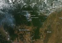
Multiple fires are visible in in this image of the Para and Mato Grosso states of Brazil. Multiple fires are visible in in this image of the Para and Mato Grosso states of Brazil. Many of these were most likely intentionally set in order to deforest the land. Deforestation is the removal of a forest or stand of trees where the land is thereafter converted to a nonforest use. Examples of deforestation include conversion of forestland to farms, ranches, or urban use. The herringbone-patterned tan lines cutting through the dark green of the Amazon Rainforest in the middle of the image are evidence of deforestation in the Brazilian state of Pará. The deforestation in Pará follows the Brazialian national motorway BR 163, passing by cities such as Novo Progresso. The lower half of the image shows the state of Mato Grosso.
The beginning of the forest loss coincides with a 1979 decision by Brazil's Program of National Integration to build roads across the forest and offer cheap land for agriculture, thus encouraging a population boom in the area. Images of the "fishbone" deforestation in Rondônia state were widely publicized, and have become the visual shorthand for tropical deforestation worldwide as evidenced in this Aqua image.
In recent decades the locus of deforestation in Brazil has shifted east to the states of Mato Grosso and Pará (seen in this image), where large tracts of land are being cleared for mechanized agriculture, rather than small-hold farming. Even so, Brazil's overall rate of deforestation has slowed in recent years.
This natural-color satellite image was collected by the Moderate Resolution Imaging Spectroradiometer (MODIS) aboard the Aqua satellite on August 15, 2014. Actively burning areas, detected by MODIS's thermal bands, are outlined in red.
Source : robert.j.gutro@nasa.gov
 Mail to a Friend