Print Article
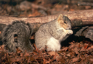
Delmarva fox squirrel. Credit: U.S. Fish and Wildlife ServiceTwo rare species, California spotted owls in the Sierra Nevada and the Delmarva fox squirrel in the mid-Atlantic U.S. have something in common. Using NASA technology, scientists have been able to identify habitats to help forest managers monitor and protect these species and other wildlife.
The recent research shows that airborne laser scanning with Light Detecting And Ranging (LiDAR) can be especially valuable in ensuring that forests and other lands continue to be diverse, healthy, and productive, while still meeting the needs of society and the environment. The study, funded by the NASA/University of Maryland Vegetation Canopy LiDAR (VCL) mission and a NASA Interdisciplinary Science (IDS) Program grant, was published in the June 2005 issue of the journal Remote Sensing of the Environment.
"When we compared the data gathered from the LiDAR, including information on canopy height and cover, to measurements taken on the ground, we found that LiDAR was very accurate, even in extremely rugged mountainous terrain," said Peter Hyde of the Department of Geography, University of Maryland-College Park, and lead author of the study. "The use of such technology is advantageous compared with field-based measurements of forest structure that are very time consuming and often limited by accessibility, resulting in relatively small field studies."
The research flights, using NASA's C-130 aircraft, took place in the Sierra Nevada mountains in northern California in 1999. A unique LiDAR, called the Laser Vegetation Imaging Sensor (LVIS), was used. It was built at NASA's Goddard Space Flight Center (GSFC) in Greenbelt, Md., and contains five lasers that send pulses of energy to the Earth's surface. Photons from the lasers bounce off leaves, branches, and the ground and reflect back to the instrument.
By analyzing returned LiDAR signals, scientists receive measurements on a forest's canopy, the layer formed by the leaves and branches of the forest's tallest trees. They also get information on tree height and biomass, the amount of living material in a given area. All of this provides a three-dimensional look at forests and represents a significant improvement over earlier radar and other technology that were not able to penetrate thick forest cover very well.
"LiDAR can also effectively distinguish and map old-growth forests, a feat that is difficult with other technology, said Principal Investigator Ralph Dubayah, also of the Department of Geography, University of Maryland-College Park.
A similar study looked at the role of forest structure on a specific animal habitat, and was led by Ross Nelson, a physical scientist at GSFC. By using data from NASA's airborne LiDAR, called the Portable Airborne System (PALS), the researchers examined about 800 miles of forest in Delaware in the summer of 2000. They also found LiDAR to be successful, especially in locating tall, dense forests that might support endangered Delmarva fox squirrel (DFS) populations. The study was also published in the June 2005 issue of the journal Remote Sensing of the Environment.
"Perhaps the most surprising finding was that about 80 percent of the forests that we identified as tall and dense could serve as a suitable habitat for the DFS," said Nelson. "But, ground visits would be needed to determine if each site is suitable for DFS reintroduction." DFS, which plays an important role in its ecosystem by distributing tree and other plant seeds, live in mature pine and hardwood forests, especially near farmland. Large trees provide an abundant supply of acorns and seeds for food and provide suitable nests. The conversion of forests into agricultural land, development, timber harvesting, sea level rise and over-hunting have all contributed to the decline in DFS populations.
In order to protect the DFS habitat, biologists rely on up-to-date information to identify habitats where food and potential nest locations are plentiful. "In the future, say every 5 years, we can follow the same flight paths used in this study to determine if habitat has been lost or gained," said Nelson.
Airborne LiDAR and similar techniques are also being used to help monitor and reintroduce other endangered species around the world, like the northern spotted owl that typically resides in old forests in Oregon and California, where trees are more than 100 years old.
Source : NASA/Goddard Space Flight Center--EOS Project Science Office
 Mail to a Friend